The purpose of this site is to chronicle the changes that the Meade County Quarry LLC "MCQ" will impact to the river front along the rock cliffs on the Kentucky shore of the Ohio River. This is a favorite destination for Ohio River boaters trying to avoid the congested river around Louisville. I would hope this will garner support for any future destruction of any other endangered natural beauty. I am in a unique location to record all of this happening directly across the river from my front door. I don't have to go any where to take pictures I just open my front door.
It's interesting to note that little progress has occurred since the project was first initiated. A down turn in the economy halted the investment capitol necessary to go forward. The same thing could happen again leaving the river front destroyed. One of the arguments put forward on the MCQ web site was "Our environment needs the scrubber stone that will help keep our air clean". There are several other quarries that supply this material with existing contracts and they are not at full production. In the interim many coal fired plants along the Ohio have switched to natural gas with no need for this product. How can MCQ compete in this environment and if unable to, do the Chicago investors just close up shop with a hole in the ground and go home? I don't fault the Chicago investors with their tunnel vision toward the profit margin without regard to the loss of beautiful river front, at one point in the past their Chicago river was so polluted that it caught fire.
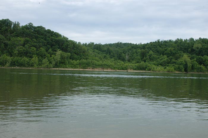
It's taken tens of thousands of years for the natural flow of the Ohio River to carve out the beautiful rock cliffs along the Ohio. Can we as custodians of this earth decide to eradicate such beauty for such a short term commercial gain? How do our needs in the life expectancy of this quarry operation stack up against the loss to all future generations. It is built into our DNA to appreciate beauty in nature and we are rapidly loosing a good deal of it that stimulates us.
Fifty years may be a long time but fore ever is a very very very long time.
I have several friends that have taken boats down the Ohio river from Louisville to the Gulf of Mexico and they have all agreed that the stretch of the river from Louisville to Evansville is unsurpassed for beauty compared to any other portion of the river all the way to New Orleans. If the Army Corps of Engineers approves this venture this web site will show on a weekly basis the slow destruction of the Ohio River Palisades as they give way to progress. I feel it my responsibility to bring as much of this devastation as possible to public awareness. Some of the activity will be posted to YouTube and video footage to this site as well
The Army Corps of Engineers is currently exploring safety issues with regard to a barge loading facility, the details of which can be accesses from the links to the left. According to their mandate and I quote from their web site :
"The benefits which reasonably may be expected to accrue from the proposal must be balanced against its reasonably foreseeable detriments. All factors which may be relevant to the proposal will be considered; among those are conservation, economics, aesthetic values, general environmental
concerns, historic values, fish and wildlife values, flood damage prevention, land use, navigation, recreation, water supply, water quality, energy needs, safety, food production, and in general, then needs and welfare of the public".
If the above underlined things are considered at all it will be obvious the none are served by approving this quarry loading facility.
For a view of how it looks today please visit my video on YouTube.
Lets hope the Corps fulfills it's responsibility to the environment and places the financial gains of the Chicago investors in second place.
For comments and any thing you would like posted to this site please send me an e-mail to Robert George
For additional information click on the links below